9.3.1.1 Step 1: Prospect Creation after Seismic Interpretation
| Topic Version | 1 | Published | 09/11/2015 | |
| For Standard | RESQML v2.0.1 | |||
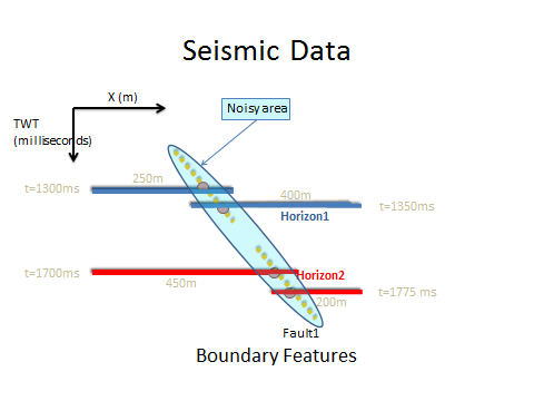
Two teams of geophysicists and geologists, one led by Paul the other by Peter, are each working with the same data on the same task: to obtain the best fit between the seismic image (seismic reflector) and two 2D grids for Horizon1 and Horizon2, and the best fit between the seismic image (noise area) and (a set of lines) for Fault1 ( Figure 9.3.1.1-1 , left). The teams are each using seismic interpretation Software A. (In reality, the geologists might be using log analysis software, but for simplicity of the example we have both groups using the same Software A.)
Software A uses an EPSG code for geographic localization and a user has interpreted a seismic cube and several seismic 2D lines. Horizon1 and Horizon2 are two reflectors corresponding to well-known genetic boundaries in this survey. These well-known genetic boundaries are the Horizon1 and Horizon2 features, which the team creates in the software. By definition, each RESQML top-level feature has a UUID (for this example: HORIZON_1_UUID, HORIZON_2_UUID, FAULT_1_UUID) In Software A, Paul and Peter picked these reflectors, and for each reflector, a 2D grid (Grid2D) was defined.
To manage their results in Software A they name them: Horizon1_Paul, Horizon2_Paul, Horizon1_Peter, Horizon2_Peter, Fault1_Paul, Fault 1_Peter, Figure 9.3.1.1-1 , right).
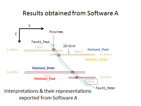
Each of their interpretations is fine, but the results are not identical, with two different interpretations of seismic reflectors and faults lines. They have calculated the potential volume between Horizon1 and Horizon2 and they have different estimations, so they want to export the data from their respective interpretations to Software B, surface modeling software, where they can create triangulated surfaces for more precise results and comparison.