9.2.2.3 Organization Interpretations
| Topic Version | 1 | Published | 09/11/2015 | |
| For Standard | RESQML v2.0.1 | |||
Technically, an organization interpretation:
- Is typically composed by one stack of its contained elements.
- Typically contains:
- contacts between the elements of this stack among themselves
- contacts between the stack elements and other organization elements
- May be built on other organization interpretations.
The feature interpretation set is used to specify collections of unordered interpretation features. For example, this class can be used to specify fault sets in a structural organization interpretation.
RESQML distinguishes these types of organization feature-interpretations, which are described further below: structural, stratigraphic, rock fluid, and earth model.
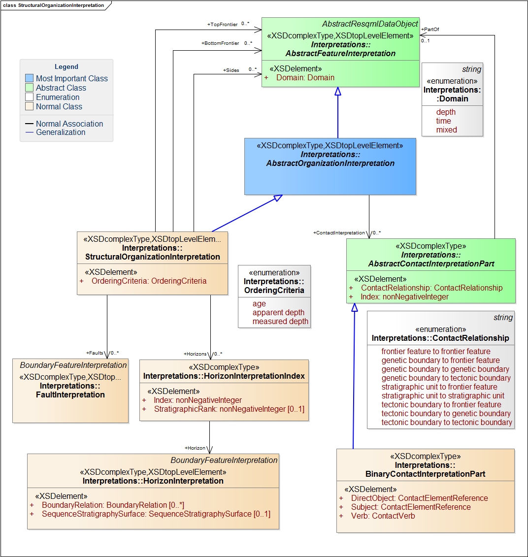
- A structural organization (Figure 9.2.2.3-1) contains the boundary interpretations (and the frontiers) that are present in a given volume or rock and their contact interpretations, which includes the contact kinds listed Section 9.2.2.2 Contact Interpretations .
A structural organization interpretation instance corresponds to a complete description of the architecture of an earth volume. It includes an ordered list of horizon interpretation indices and a list of fault interpretations. Note that to define a fault network, we used a list of fault interpretations plus a “tectonic boundary to tectonic boundary” contact interpretation.
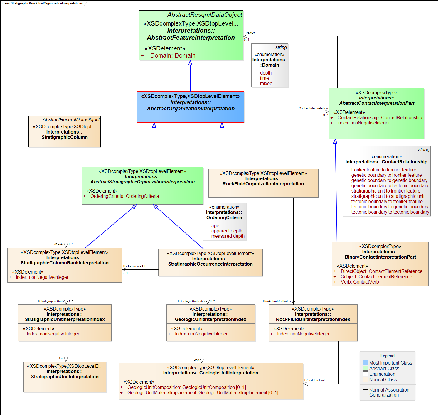
- Stratigraphic organization interpretation defines the relationships between stratigraphic units. Figure 9.2.2.3-2 shows this class along with the child classes it comprises, which are :
- Stratigraphic column interpretation corresponds to the type of assemblage commonly designated by geologists as a stratigraphic succession or simply as “stratigraphy”. It is a global hierarchical level that can be made up of several ranks of stratigraphic units; all ranks are ordered by age or apparent depth. (BUSINESS RULE: You cannot mix ranks by age and depth in the same stratigraphic column). NOTE: All the ranks referred to by the stratigraphic column should point to the same stratigraphic organization feature, which implicitly associates the column to the feature.
- Stratigraphic occurrence interpretation designates a local succession of geological units arranged according to an ordering criterion, which are present along a well, on a 2D map or on a 2D section, or on a part of the global earth volume. Ordering criterion may be age, or apparent or measured depth along a well trajectory. It is equivalent to stratigraphy occurrence defined by Perrin and Rainaud (2013) (which states: "A stratigraphy occurrence is defined as an assemblage of units and boundaries, whose arrangement agrees with a stratigraphy.")
NOTE: It is not possible to introduce geobodies and geobody boundaries in a structural/stratigraphic organization interpretation. In this situation, to specify the interpretation for a geologic boundary feature, use a horizon interpretation.
- Rock Fluid Organization (Figure 9.2.2.3-2) is composed of rock fluid units. This part has not been completely evaluated and will be considered with more details in a future version of RESQML.
After initial evaluation (which is still ongoing), we observed these issues:
- A rock fluid organization interpretation can gather only ONE rock fluid unit interpretation index/ geologic unit interpretation; it should be multiple. If more than one rock fluid organization interpretation is needed, use stratigraphic occurrence interpretations with organization kind attributes set to "fluid".
- To define the fluid contacts:
- Use boundary feature with a fluid boundary interpretation with a plane set representation.
- Do NOT use rock fluid organization interpretation to group them in a contact set; instead, use a representation set representation.
- Link the regions to the planes by using the outer ring of the patch boundaries of the plane set representation (inherited from abstract surface representation). NOTE: You should have the same number of patch boundaries as planes (pointing either to subrepresentations or to the entire representation).
- Earth model organization interpretation(Figure 9.1.3-1) refers to a “trusted” interpretation of a geological site at a definite stage of the modeling process; “trusted” means that this interpretation should be geologically and topologically consistent. Additionally, for an earth model organization to be considered trusted, the rock fluid organization interpretation must be based on the stratigraphic organization interpretation and the stratigraphic organization interpretation must be built on a structural organization interpretation. Thus an earth model rests on various kinds of organizations describing the stratigraphic, structural, and rock fluid characteristics of the model.